


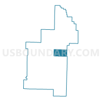
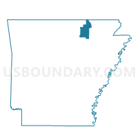
North Lebanon Voting District, Sharp County, Arkansas
About
Outline

Summary
| Unique Area Identifier | 528228 |
| Name | North Lebanon Voting District |
| County | Sharp County |
| State | Arkansas |
| Area (square miles) | 18.01 |
| Land Area (square miles) | 18.01 |
| Water Area (square miles) | 0.00 |
| % of Land Area | 100.00 |
| % of Water Area | 0.00 |
| Latitude of the Internal Point | 36.18077440 |
| Longtitude of the Internal Point | -91.40510720 |
Maps

Graphs
Select a template below for downloading or customizing gragh for North Lebanon Voting District, Sharp County, Arkansas


Neighbors
Neighoring Voting District (by Name) Neighboring Voting District on the Map
- Davidson Voting District, Sharp County, AR
- Jackson Voting District, Sharp County, AR
- Morgan Voting District, Sharp County, AR
- South Lebanon Voting District, Sharp County, AR
- SPRING RIVER Voting District, Lawrence County, AR
Top 10 Neighboring County Subdivision (by Population) Neighboring County Subdivision on the Map
- Spring River township, Lawrence County, AR (374)
- Jackson township, Sharp County, AR (295)
- Morgan township, Sharp County, AR (233)
- Davidson township, Sharp County, AR (167)
- South Lebanon township, Sharp County, AR (110)
- North Lebanon township, Sharp County, AR (59)
Top 10 Neighboring Unified School District (by Population) Neighboring Unified School District on the Map
- Highland School District, AR (11,696)
- Hillcrest School District, AR (3,680)
- Twin Rivers School District, AR (3,374)